
The ‘portable port’: New Orleans was built on shipping, but its center of gravity continues to shift | Entertainment/Life

Unlike port cities, which usually expand outwardly from fixed historical cores, ports themselves tend to be rather portable. Needing to accommodate changing economies and technologies, the wharves and facilities for loading and unloading vessels are often moved to more versatile spaces, else shippers will opt for better ways to get goods to market.
Maritime activity in New York City, for example, was once centered on Manhattan Island; now it’s in the outer boroughs and New Jersey.
Ships that once called at San Francisco now go to Oakland, while those that dock at Seattle can also go to Tacoma.
New Orleans’s port, too, has shifted over the centuries, and another big move appears to be forthcoming.
Last month, the Board of Commissioners of the Port of New Orleans unanimously approved the acquisition of 1,100 acres in the St. Bernard Parish community of Violet, fronting the Mississippi and straddling the Violet Canal.

A downriver expansion: The Port of New Orleans has an agreement to buy a 1,100-acre site along the Mississippi River in Violet to serve super-sized cargo vessels.
The chief motivator behind the downriver expansion is to accommodate the next generation of containerized ships, which are designed to take advantage of the recently widened Panama Canal. These enlarged vessels have higher vertical clearance and deeper water-draft needs than those that currently dock at the Uptown wharves.
Docking at Violet would avoid the height restriction imposed by the Crescent City Connection, and benefit from the current Army Corps of Engineers program to dredge the river to a depth of 50 feet. This semi-rural part of St. Bernard Parish has the available space, while still being within the federal levee system. Being farther downriver, it also eliminates 15 miles of river navigation in each direction, saving time and fuel.
It’s not yet a done deal. The land purchase still needs to be finalized, after which there will be “a two-year due diligence and permitting period that will include robust community engagement,” according to a Port press release.
The planned move isn’t expected to affect the Uptown container wharves. “Port NOLA will continue to invest in and utilize our existing Napoleon Avenue Container Terminal in New Orleans,” the press release said. Rather, the new Violet project “will increase our capacity to handle projected demand and ample acreage to support ancillary logistics and value-added businesses to meet the industry’s evolving needs.”

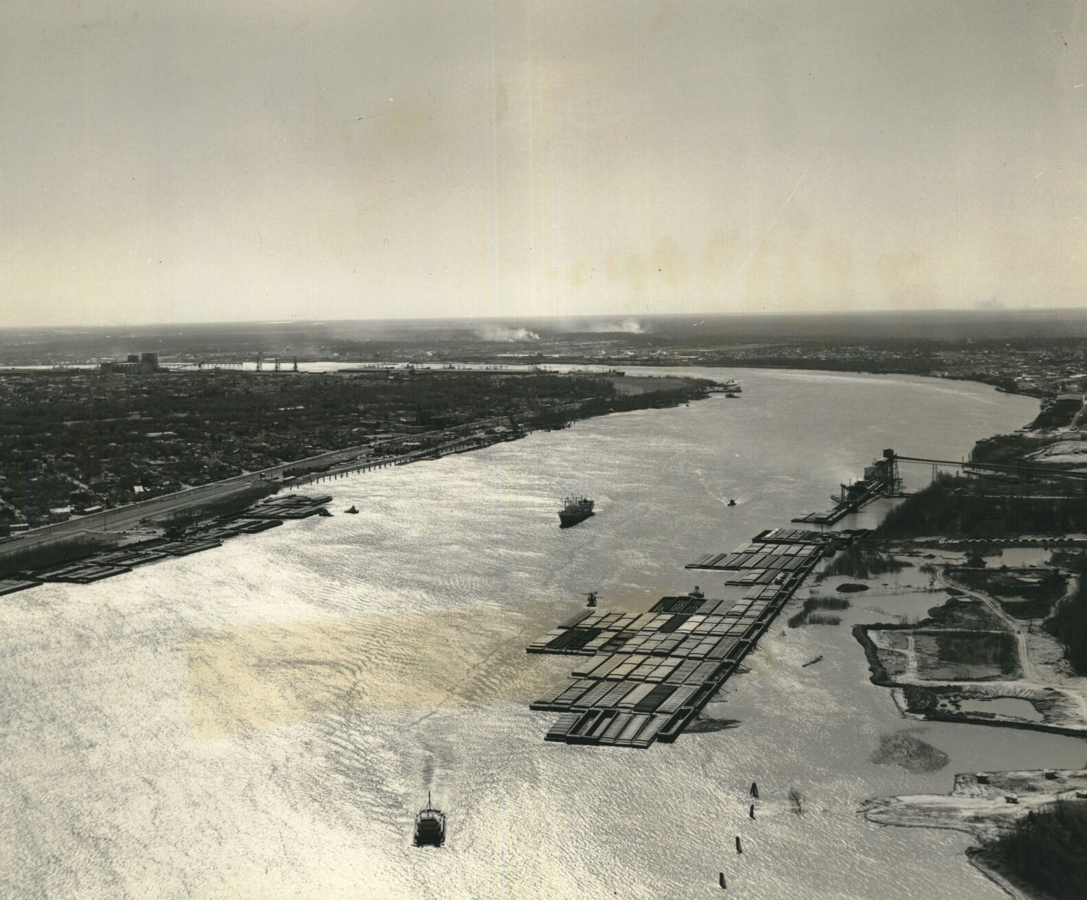
The Port of New Orleans, photographed Jan. 29, 2020.
But the board’s approval represented a significant milestone, and it signals the latest in a sequence of port expansions and relocations dating back to the earliest days of Louisiana.
The colonial port
“A port or two (here) would make us masters of the whole of this continent,” wrote Robert La Salle to King Louis XIV of France, after claiming Louisiana in his name in 1682.
It would take 36 years to make good on that vision, when Bienville established New Orleans in 1718. Like La Salle, Bienville realized the colony’s premier city ought to be near the mouth of the Mississippi River, for defensive reasons but also to serve as an entrepôt, or transshipment port.
For decades to come, most maritime activity at New Orleans occurred directly in front of the original city, today’s French Quarter, as well as at a depot in present-day Algiers Point known as the Company Plantation.
But New Orleans needed help to get the shipping job done. Because strong currents and treacherous shoals made it difficult to sail up the mouth of the Mississippi, engineers in 1722 established a tiny entrepôt at the river’s mouth. Known as Balize (“beacon”), this precarious facility allowed ocean-going ships to transfer their cargo to smaller vessels for the 95-mile river trip to New Orleans.
Balize later became obsolete and was eventually swept away by the river. But the eastward-leaning, downriver-trending pull of port activity that motivated its creation would persist.
In 1788, New Orleans expanded upriver into the present-day Central Business District, and port activity soon followed, as vessels docked along what is now the Warehouse District riverfront. Because this bank was shallow and prone to sand deposits, piers perpendicular to the bank were installed into deeper waters for vessels to moor.
‘Leading port of the world’
Starting in the 1810s, steamboats began calling at New Orleans, and soon scores of them jockeyed for space alongside ocean-going sailing ships, coast-wise schooners, and river craft such as flatboats and barges.
Port officials generally directed sailing ships, because they came upriver from the Gulf, to the lower wharves, from around Conti Street down to the Faubourg Marigny.
Flatboats, which came down from the “upcountry,” moored at the upper wharves, from Julia up to Felicity Street.
Steamboats took center stage, docking on either side of the foot of Canal Street, from Conti to Julia.
Together, the port made for a dazzling sight. Visitors in the 1830s marveled at its ant-like “bustle and confusion” set against “a forest of masts;” one called it “the most extraordinary medley of…craft of every possible variety.”

The port of New Orleans in 1870
By one estimate, New Orleans ranked as “the fourth port in point of commerce in the world, exceeded only by London, Liverpool, and New York;” by another, it was “the leading export city of the United States and one of the leading ports of the world.”
The port in the early 1800s was not a formal entity overseen by a single agency, as it is today. Rather, city, state, and federal officials all had a hand in administration.
The city enacted ordinances and regulations, while the governor appointed a harbor master and various assistants to oversee day-to-day operations.
At the federal levee, a presidentially appointed collector of customs controlled outbound vessels, collected duties and policed against smugglers and pirates.
By 1860, port activity had expanded to four miles along the river, from the Faubourg Marigny to the Irish Channel, as well as other wharves farther uptown and in Carrollton, three mini-ports on Lake Pontchartrain, ship-building and dry docks on the West Bank and dozens of smaller landings fronting sundry industries and plantations.
But troubles were brewing. Canal excavation in the North, and an ever-growing network of railroads, had been letting more and more western cargo move eastward, rather than southward down the river to New Orleans. The outbreak of the Civil War triggered a blockade on shipping. All the while, silting had impeded navigation at the mouth of the Mississippi.
Move the port?
After the war, private interests vied to reinvigorate trade by circumventing the river’s silting problem, along with its high pilotage fees.
In 1868, the New Orleans and Ship Island Canal Co. proposed a radical plan to dig a 150-foot-wide, twelve-foot-deep navigation channel from present-day Old Metairie eastward all the way to Lake Borgne and on to the deep harbor of Ship Island, off present-day day Gulfport.
A later version had the seaway’s western terminus adjoining the Mississippi River with a gigantic lock, near an inland harbor carved into the Fontainebleau area.
The West Bank had its own river-circumventing scheme. In 1878, Congress authorized the Barataria Ship Canal Co. to dig a deep-draft seaway southward across the Barataria Basin to the Grand Isle area, aiming to “be the only gate through which the largest ships will reach the port of New Orleans,” as the Daily Picayune explained.
Neither proved necessary, because the brilliant nautical engineer Capt. James Eads had a better solution to the silting problem: constructing parallel jetties at South Pass to constrain the water flow, increase its velocity, and scour out the sediment.

The steamboat landing at the port of New Orleans, seen here in 1902.
“Eads’ jetties,” completed in 1879, worked perfectly. With the lower Mississippi now passable, the seaway proposals died out, sparing New Orleans what probably would have been an environmental and economic disaster.
But, like the Balize concept, the idea of a manmade seaway and inland harbor would persist.
Come the railroads
New Orleans in the late 1800s raced to catch up with railroads’ investments in competing port cities. New track beds were built here to connect to wharves, and shipping firms and railroad companies worked in tense unison to move cargo, even as they competed elsewhere.
Port operations by this time had become problematic. The leasing system, in which the city rented wharf space to private operators, gave leaseholders little incentive to maintain wharves, and every incentive to overcharge for their use.
City officials, for their part, failed to keep up with the latest technologies, such as steam-powered grain elevators and specialized warehousing facilities. Something had to be done.
In 1896, the state Legislature restructured local maritime activity under the authority of a new state agency, the Port of New Orleans. Guided by a governor-appointed Board of Commissioners (“the Dock Board”) and run like a business by an executive team of experts, this capital-P Port was charged with administering all public wharves and maritime servitudes while regulating traffic and trade.
The new board worked assiduously to modernize facilities, creating, among other things, the mile-long Stuyvesant Docks along the Uptown riverfront, complete with power generators, pavilions, platforms, grain elevators and an integrated railroad network. It also helped form the city-owned New Orleans Public Belt Railroad, which gave private rail operators consolidated access to wharves.
Grain barges await discharge at the port in 1967, illustrating New Orleans’ rank at the time as the world’s largest exporter of grain.
Most significantly, the board had the Inner Harbor Navigation Canal dug through the Ninth Ward, connecting the Mississippi River with Lake Pontchartrain. Started in 1918 and opened in 1923, the “Industrial Canal” shifted the fulcrum of port activity eastward and off the Mississippi. Former swamplands became valuable wharf space around a stable-water inner harbor, which could be leased out for bulk cargo, vessel-building, value-added industries, and storage.
The same was happening on the West Bank, when the Army Corps of Engineers selected the Harvey Canal to host the Gulf Intracoastal Waterway, a public canal being built to run from Texas to Florida and continue up the Eastern Seaboard. Soon, new industries lined its banks as well.
In 1943, the Intracoastal was extended through eastern New Orleans, allowing domestic barge traffic to spend less time on the Mississippi. All the more, the fulcrum tilted eastward.
Seaway proposals
The spate of canal-building enticed shipping interests to once again “think big.” Why battle the currents and meanders of the Mississippi when you can dig a tidewater channel and relocate the port to its flanks? It seemed to work for barge traffic; why not for ocean-going vessels?
East Bank interests proposed cutting a seaway eastward through Lake Borgne to the Mississippi Sound, an idea not unlike the Ship Island Canal scheme from the late 1860s.
The idea was nicknamed “the Alexander Seaway,” for former Dock Board president Col. Lester F. Alexander, who had advocated for it since the early 1900s.

In 1961, industry and the port of New Orleans were looking to the east, as construction progressed on the Mississippi River-Gulf Outlet. The outlet was conceived as a way to give New Orleans a second and significantly shorter route to the Gulf of Mexico. The so-called MR-GO didn’t operate as envisioned, however, and it made the city more vulnerable to hurricanes. It was closed permanently after 2005’s Hurricane Katrina.
It gained momentum in 1946 when famed New York planner Robert Moses envisioned an enormous harbor facility carved into the marshes east of the Industrial Canal, adjoining what Moses called the East Bank Tide Water Ship Canal. The proposal appeared in his “Arterial Plan for New Orleans,” best known for broaching the later-infamous and eventually cancelled Riverfront Expressway.
West Bank advocates wanted in on the action. They proposed something similar to that Barataria Ship Canal idea of 1878, only grander — a 55-mile long seaway cut across the Barataria Basin, with a huge inland harbor and lock at Westwego, and a mouth by Grand Isle.
The East Bank proposal won out. Dug in four phases starting in 1958, the channel would fork off from the Intracoastal in eastern New Orleans and continue southeastwardly for 40 miles through St. Bernard Parish to Breton Sound.
This time, the big ditch was dubbed the Mississippi River-Gulf Outlet Canal.
After it was completed in 1968, planners conceived an even more radical shift of port activity. It would be called “Centroport,” and the name said it all.

A Port of New Orleans security guard is the lone figure on the docks as a 1977 general strike by longshoremen completely shut down the port. The strick led vessels to be held at the mouth of the Mississippi River, with no work being performed anywhere on the docks.
Maritime activity would move off the Mississippi River en masse to vast new centralized facility in eastern Orleans Parish, where barges could use the Intracoastal, where ocean-going vessels could ply the MR-GO, where there was plenty of space for cargo, and where railroad lines and the new Interstate 10 could provide intermodal transportation.
Historian Leonard Huber in 1971 wrote that Centroport would “free the banks of the Mississippi of the unsightly steel sheds” and allow “for development of choice high-rise riverfront apartments, hotels, tourist terminals, (and) riverfront parks.”
Geographer Peirce Lewis predicted in 1973 the port’s pending eastward shift would represent “the most drastic change in New Orleans economic geography since the city’s founding.”
For a while it looked like it might happen, with the creation of the France Road Terminal and the erection of its towering blue cranes.

A ship loaded with bananas sits idle at the Erato Street dock in 1974. Movement of bananas through the Port of New Orleans was drastically curtailed amid labor unrest; eventually, fruit shippers began sending their cargo through ports in Mississippi instead.
But then problems started to develop. The Industrial Canal’s narrow lock became a bottleneck for barge traffic. Bankside erosion along the MR-GO required constant and costly dredging, else ships had to lighten their loads and lose money.
Firms hesitated to relocate their facilities eastward, which discouraged shippers from sailing there. Usage of the MR-GO diminished.
Intended practically to replace the Mississippi River for large-scale navigation, the MR-GO instead carried only 11% of port tonnage by 1990, and 5% by 1998. Meanwhile, coastal land loss and storm surge risk mounted.
Retreat to the river
By century’s end, maritime activity refocused on the Uptown river wharves, with leaders aiming to expand and consolidate the Napoleon and Nashville Terminals into a “mega-wharf,” while upgrading facilities at the Henry Clay Wharf.
The Port’s eastward shift instead became a westward reinvestment back on the Mississippi, as well as a spatial concentration at certain wharves. That is, containerization technology had the effect of intensifying activity to where cranes, gantries, rails, and truck access were located.
Other wharves, where cargo ships from Central America and elsewhere once moored, now went empty, a transformation furthered by the tropical fruit trade’s relocation to Gulfport, Mississippi, largely on account of labor discord.
Hurricane Katrina in 2005 further illustrated what a fiasco the MR-GO had been, as it allowed surge to penetrate the metropolis from the east, leading to catastrophic breaches of under-engineered federal floodwalls. The coastal erosion it had helped cause during the prior 40 years exacerbated Katrina’s surge and flooding.
Congress closed the MR-GO to navigational traffic, and the France Road Terminal equipment was relocated back to the Mississippi River—where Bienville had wanted the port to be in 1718, and where La Salle foresaw it would be needed in 1682.
The retreat seemingly ended the centuries-long story of the portable port.

Here, longshoremen unload Japanese steel at the Harmony Street wharf in 1987. At the time, forecasters saw bad news for New Orleans in the growing trade tensions between the Japanese and the U.S. The waning value of the dollar caused the Japanese to slow their exports, particularly of steel.
But the drivers behind these shifts are more global than local, and they continue to tug maritime activity toward spaces of greater convenience and fewer obstacles—that is, eastward and/or downriver, closer to global commerce.
In the late 1990s, officials contemplated a “Millennium Port” somewhere along the river in lower St. Bernard or Plaquemines Parish. And in 2000, the Millennium Port Authority suggested building a containerized cargo terminal at Head of Passes, a resurrection of the entrepôt role of historical Balize.
Now, as post-Panamax ships beckon and world ports race to accommodate them, authorities at the Port of New Orleans are devising the next chapter in the story of the portable port—and it appears its address will be at Violet in St. Bernard Parish.
-Richard Campanella, a geographer with the Tulane School of Architecture, is the author of “The West Bank of Greater New Orleans,” “Bienville’s Dilemma,” “Cityscapes of New Orleans,” and other books. He may be reached at [email protected], http://richcampanella.com, or @nolacampanella on Twitter.


